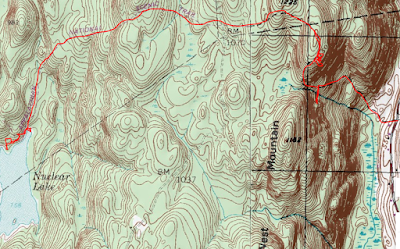
Headed south this afternoon to hike a scenic stretch of the Appalachian Trail in Dutchess County. Parked along the shoulder of West Dover Road beside the well known Dover Oak, where the Appalachian Trail crosses the road. The Dover Oak is thought to be at least 300 years old with a circumference of over 20 feet and is the largest blazed tree along the entire length of the AT. It is quite an impressive site!! Even more impressive is that with the leaves off the trees, the ledges that make up Cat Rocks can clearly be seen as well. Elevation to start was just under 550 feet.
I crossed the road and headed west, first dropping down through a wet section on puncheon, before beginning to climb. The trail heads steeply up along a rock spine, gaining elevation quickly before dropping off the spine and back into woods.
The route remains steep, soon arriving at a spur trail to the Telephone Pioneers Shelter. I took this blue blazed spur trail over to the shelter, which sits on a steep hillside, near a small drainage.
From inside the shelter, there are screened views to the valley below.
Once back on the main trail, a short but steep climb brought me up to the main ridge and within a few minutes, I arrived at Cat Rocks. The views from these ledges are very nice, and stretch from NE to SE. Here is a look SE towards Pawling.
I explored the ledges for a few minutes, checking out the various vistas. The nearly vertical drop off on the east side provides great views all the way east into Connecticut,
NE views from a lower spot on the ledges.
A zoom view towards Pawling.
When exploring steep ledges like these, you must be careful with your footing, as you never know when a large crevasse, such as this may appear.
From a spot just below the ledges, I caught this incredible look at the geological formation known as Cat Rocks.
After enjoying Cat Rocks for a while, I finally continued on the trail, heading west through rolling terrain. Passed by this large vernal pond next to the trail which was fee of any ice...
...but less than 1/10 of a mile further, in a slightly sheltered location, this vernal pond held onto its ice(although it was melting fast with temps closing in on 50)
One of the best parts of traveling a well used trail such as this, is that it has all the amenities(at least in the hiking world), such as puncheon in wet areas.
I found many, many old stone walls in these woods, offering up a glimpse into the past. It is quite obvious that these woods were almost certainly farmed before nature reclaimed them.
After a long, quiet stretch in the woods, I arrived at the north shore of peaceful 55 acre Nuclear Lake. I wandered the west shore for a bit, stopping at a cove to take in this serene shot.
Heading back to the north end of the lake, I dropped down to the shore to soak in this view. Although a nearby chemical plant named the lake back in the late 1950's, it was in 1972 that ironically a chemical blast fueled fears that the lake had been contaminated. After years of cleanup and testing which proved that the lake was clean, the lake received a clean bill of health. Thankfully today, the public can enjoy the lake that is often considered one of the more beautiful sections of the AT.
After enjoying the serenity of the lake, I turned back, retracing my steps towards the car. One interesting spot that I passed, was Penny Road, which shows up on my map, but is nothing more than an old woods road, lined by stone walls on each side.
The quiet hike back eventually brought me to Cat Rocks, which I had to check one last time.
Hiked about 7 miles RT, with over 1700 feet of ascent along a gorgeous stretch of the Appalachian Trail.
With time to kill, I took the scenic route home, passing through rural Dutchess and Columbia County's. The less traveled roads sometimes provide a glimpse into a much slower pace of life, such as this farm in the town of Ghent.


No comments:
Post a Comment