Headed down to the beautiful Litchfield Hills in the NW corner of Connecticut this afternoon to do a little exploring along the north ridge of Mine Mountain. Mine Mountain is actually a long north-south ridge with multiple summit knobs sitting high above the east banks of the Housatonic River. To access the mountain, I utilized the Trinity Riverside Trail, which can be found at the very end of Lower River Road, and begins on Trinity Retreat Center Property before entering the Housatonic State Forest.(Elevation at the Trailhead is just a touch over 500 feet). With the sun shining bright and the trail well used I threw my spikes on and headed south, closely hugging the Housatonic.
(FYI-The public is welcome on Trinity Retreat Center property)
The Housatonic River is just steps away from the trail, which heads south for 1.4 miles.
After about a half mile on the trail, I turned left and began my bushwhack, crossing over the Housatonic Railroad tracks.
The woods are very, very steep but manageable if you pick out a good route. It was actually quite fun and challenging, gaining over 500 feet in less than a quarter mile.
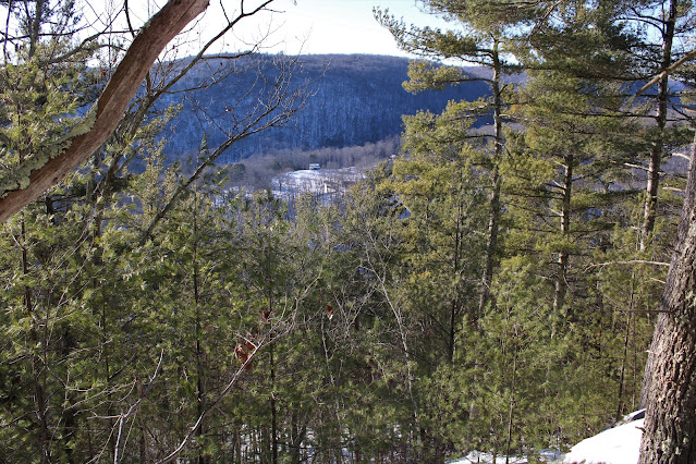
The snow actually helped me gain traction in steeper parts, and I was able to enjoy some pretty good views back west on the way up.
Instead of going straight up, I contoured my way south towards an area of ledges. From a small perch I was able to enjoy a spectacular view south over the deep River valley, with Mine's true summit(left) as well as Breadloaf Mountain and Silver Mountain in the distance. To the far right, and almost out of frame is Pine Knob.
After taking in the views, I headed north along the ridge on a blue marked trail, which apparently doesn't see much use, as there were no tracks in the snow at all.
From the very end of the north ridge, and directly above the Trinity Retreat Center, I found amazing NW facing views across the River towards Pine Swamp Hill's multiple summits.
West views with the Housatonic River directly below.
The toughest part of the entire hike was trying to find a route down, as the slopes are quite steep both north and west. The easiest descent appeared to be on the east slopes, so that is the way I went, carefully weaving my way down. Once off the steepest slopes, I circled around to the north, leaving the State Forest and heading across Trinity property back to my car. A fun little adventure on a cool, but pleasant mid winter day. 2.7 miles RT, with 800 feet of climbing.
Red P=Parking Black X=Ledge


No comments:
Post a Comment