Took advantage of a sunny and beautiful Tuesday morning by heading down into NW Connecticut to hike Lions Head and a section of the Appalachian Trail. I would be starting my hike from the trailhead for the Lions Head Connecter Trail on Bunker Hill Road(Elevation 1160 feet), which was plowed, although I was surprisingly the only car there. Temps were only in the single digits as I set, but quickly warmed up under clear skies and a light south breeze. The trail was well broken out and compact, making snowshoes more of a hindrance than a benefit through the 6 inches or so of snow.
The Lions Head connector trail meanders through open meadows and near residential houses, before crossing a private driveway and heading into the woods, where the climbing finally commences.

The trail climbs steadily west-then north, soon meeting up with the white blazes of the Appalachian Trail after less than one mile and over 300 feet of ascent. Once on the AT, the trail climbs a bit more steeply north, with one last scramble up to Lions Head summit at 1738 feet.


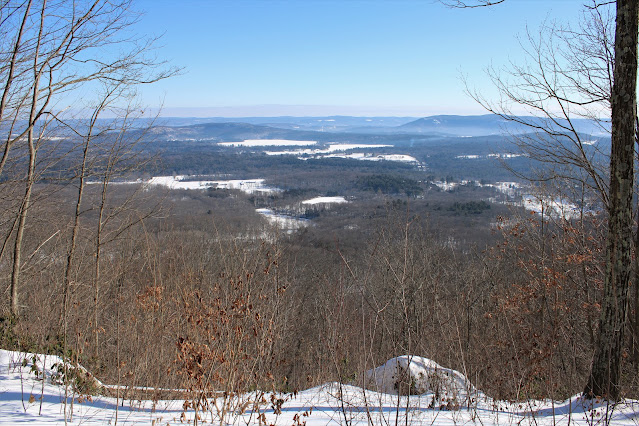
Views to the south, with the Taconic Ridge and Mount Riga to the right.


I followed the Appalachian Trail winding its way north, never dropping below 1550 feet on its way to a spur trail for the Mount Riga Shelter and Campsite. There are tent platforms, a privy and bear proof containers here, but the Lean To and its views are certainly the highlight!!

From the Shelter, I turned back, retracing my steps back over Lions Head and down to the car. Was quite shocked to not see another person all day on this beautiful mid winter day in the Litchfield Hills! Hiked 3.5 miles RT, with nearly 1000 feet of combined ascent.
That looks awesome! I am going to have to check it out; it's been a while since I was in that rugged corner of CT. That lean-to area looks like paradise...
ReplyDeleteThose hills in rugged NW CT are simply awesome!! The hike above to Lions Head and the Lean To is a perfect half day hike for when you already have prior afternoon commitments(like I did). That Lean To faces directly east and I'm sure the sunrises must be truly special from there!!
Delete