We stayed on a northeast course until hitting a fisherman path along Extract Brook, which we followed north for about a mile.
Stone chocked Extract Brook.
Just below the summit, we found the enormous open southeast facing rock slab.
The angle of the open rock was a bit intimidating, but footing was pretty good, so we got a grip and climbed up.
We were very careful with our footing because the incline was quite precarious.
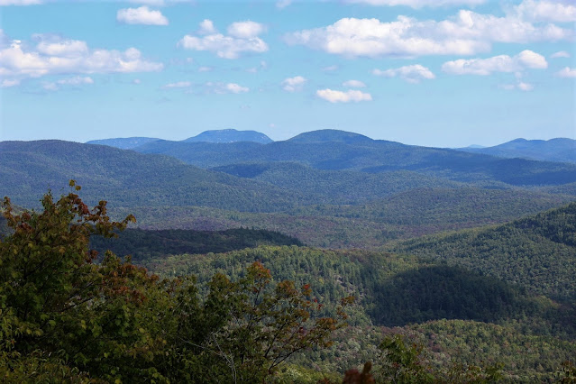
A great look in the distance towards Crane Mountain(L) and Mount Blue(R).
After enjoying the views and nice, refreshing breeze, we continued up the short remaining distance to the true summit, marked with a small rock pile.
Jim had thought he saw a small but open rock slide on the west side of the peak as well, so we bushwhacked our way over there. Unfortunately we could only find a small view point, with a nice look at an exposed rock area on nearby Macomber Mountain.
Looking over the maps, we decided to continue on down to Buckhorn Ponds, a little under a half mile north of us. We had no way of knowing that we'd be descending down through thick brush, making that half mile seem much longer. The reward was nice though, as we found a small rocky shore to stop and enjoy lunch.
Buckhorn Pond on a beautiful September day.
After lunch, we turned back, finding an easier way on the return ascent back up and over the summit. Here I am passing through some tall ferns.
We got back at about 3:30pm after about 8.2 miles and 1650 feet elevation gain.


looks familiar...
ReplyDeleteThis way made much more sense than Barbara McMartin's suggested route from County Line Brook in the old Discover Series. We really enjoyed this hike. Been looking at Hayes Mountain open cliffs in the Hoffman Notch area next I think. Ever been there?
DeleteI climbed nearby Cobble Hill in winter. I remember coming back down to Bailey Pond and seeing the cliffs on Hayes. It's on my list though.
ReplyDeleteyour the first person I've heard even mention these cliffs other than Barb McMartin. I fished Buckhorn three times following the outlet up and bushwhacked over to the cliffs from the pond. Caught a lot of 12 to 14 inch brook trout.
ReplyDeleteYeah, I couldn't find a lot of information on these cliffs...which was exactly what drew me to them. Had no idea that there was good fishing in those ponds. Did you fish the brook up as well?
DeleteI didn't fish the outlet to Buckhorn Ponds. It isn't really fishsble in that it gains a thousand feet in a mile or so. Only one of the three ponds is fishable. The other two are pretty much connected and shallow. I really like the place because the chances of seeing anyone are pretty much non existent.
ReplyDelete